


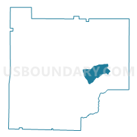
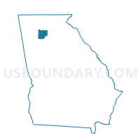
057027 - MACEDONIA Voting District, Cherokee County, Georgia
About
Outline

Summary
| Unique Area Identifier | 560651 |
| Name | 057027 - MACEDONIA Voting District |
| County | Cherokee County |
| State | Georgia |
| Area (square miles) | 9.75 |
| Land Area (square miles) | 9.61 |
| Water Area (square miles) | 0.15 |
| % of Land Area | 98.51 |
| % of Water Area | 1.49 |
| Latitude of the Internal Point | 34.23463360 |
| Longtitude of the Internal Point | -84.36394010 |
Maps

Graphs
Select a template below for downloading or customizing gragh for 057027 - MACEDONIA Voting District, Cherokee County, Georgia


Neighbors
Neighoring Voting District (by Name) Neighboring Voting District on the Map
- 057003 - AVERY Voting District, Cherokee County, GA
- 057018 - FREEHOME Voting District, Cherokee County, GA
- 057020 - HIGHTOWER Voting District, Cherokee County, GA
- 057038 - UNION HILL Voting District, Cherokee County, GA
- 057039 - UNIVETER Voting District, Cherokee County, GA
Top 10 Neighboring County Subdivision (by Population) Neighboring County Subdivision on the Map
- Holly Springs CCD, Cherokee County, GA (51,788)
- Canton CCD, Cherokee County, GA (35,700)
- Lathemtown CCD, Cherokee County, GA (17,942)
Top 10 Neighboring Unified School District (by Population) Neighboring Unified School District on the Map
Top 10 Neighboring State Legislative District Lower Chamber (by Population) Neighboring State Legislative District Lower Chamber on the Map
Top 10 Neighboring State Legislative District Upper Chamber (by Population) Neighboring State Legislative District Upper Chamber on the Map
Top 10 Neighboring 111th Congressional District (by Population) Neighboring 111th Congressional District on the Map
Top 10 Neighboring Census Tract (by Population) Neighboring Census Tract on the Map
- Census Tract 905.02, Cherokee County, GA (12,065)
- Census Tract 906.02, Cherokee County, GA (8,376)
- Census Tract 908.02, Cherokee County, GA (6,642)
- Census Tract 905.01, Cherokee County, GA (5,877)